 Washington
Washington
Washington
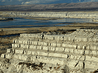
The White Bluffs tower up to 560 feet above the Columbia River like chalk cliffs transplanted from the English coast, but their story is purely Pacific Northwest. These buff-colored bluffs expose the Ringold Formation -- ancient river and...
The White Bluffs tower up to 560 feet above the Columbia River like chalk cliffs transplanted from the English coast, but their story is purely Pacific Northwest. These buff-colored bluffs expose the Ringold Formation -- ancient river and lake sediments laid down 8.5 to 3.4 million years ago by the Columbia and Snake Rivers long before the ice ages began. Then, roughly 17,000 years ago, the Missoula Floods arrived and carved new channels into these ancient deposits, leaving behind younger rhythmite layers stacked within paleochannels that record up to a dozen separate flood events. Between most rhythmite layers, wind-blown sand indicates periods of dryness between floods -- a diary of catastrophe and calm preserved in sediment. The White Bluffs line the east bank of the Hanford Reach, the longest free-flowing, nontidal section of the Columbia River, preserved by accident when the Manhattan Project sealed off the area. The massive sand dunes, the towering bluffs, and the wild river make the Hanford Reach one of the most dramatic natural landscapes in Washington, accessible primarily by boat. Where the atomic age met the ice age, nature has been left to tell its own story.
Open daily, sunrise to sunset; White Bluffs Boat Launch is open from two hours before sunrise to two hours after sunset. Free. No maintained trails, paths are user-built and follow service roads or the old wagon route; terrain is steep and unmarked. No facilities at the overlook. Contact USFWS at (509) 546-8300 for current closures (parts of the monument are subject to Hanford-related access restrictions).
The White Bluffs expose roughly 300 ft of stratigraphy along the east bank of the Columbia at the Hanford Reach, the last free-flowing stretch of the river. Most of the bluff face is the pale Ringold Formation, ancient lake and slackwater deposits laid down by the ancestral Columbia between roughly 8.5 and 3.4 Ma. The Ice Age Floods cut a paleochannel into the Ringold and then refilled it with rhythmically bedded slackwater deposits (the "Touchet beds" in this stratigraphic position) dated to 17,550–12,500 yr BP. These rhythmites are the calm-water record of Lake Lewis, the temporary lake created when Missoula floodwaters backed up behind Wallula Gap to a depth of ~900 ft over the present Tri-Cities. Each rhythmite couplet records one flood pulse settling out; the White Bluffs are one of the cleanest exposures of the Lake Lewis stratigraphy.
The slackwater rhythmite age range (17.5–12.5 ka) is now anchored on the Balbas et al. (2017) chronology and refined OSL work on Touchet-type beds (Atwater and others) consistent with the broader Missoula-flood record.
The IAFI Lake Lewis Chapter treats the White Bluffs as one of its signature stops and has produced an interpretive sheet on the bluffs at Hanford Reach. The REACH Museum in Richland is the formal indoor partner for this interpretation; the bluffs themselves have no on-site IAFI panel.
The White Bluffs North Slope trail (popular, but unmaintained) climbs the dunes atop the bluff for the canonical view down the rhythmite section. Best in spring (wildflowers, mild temperatures) or fall; summer is brutally hot and exposed. Pair with the REACH Museum in Richland for indoor interpretation.
Flood-extent overlay shows the maximum reach of the Missoula Floods.
The site in its place along the flood path, with the maximum flood extent drawn over the modern map.
View on the interactive map Searchable sites · 360° trails · flood reconstruction