 Washington
Washington
Washington
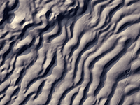
Imagine ocean waves frozen in gravel and stone, each one taller than a two-story building. The giant current ripple marks at West Bar rise up to 25 feet high and stretch 200 feet apart, created by floodwaters so deep and powerful they...
Imagine ocean waves frozen in gravel and stone, each one taller than a two-story building. The giant current ripple marks at West Bar rise up to 25 feet high and stretch 200 feet apart, created by floodwaters so deep and powerful they sculpted the riverbed the way a stream shapes sand ripples -- except at a scale a thousand times larger. This extraordinary ripple field was likely formed by an outburst flood from Glacial Lake Columbia as the Okanogan ice lobe retreated, making it one of the last great flood features created in the region. The ripples are composed of boulders and cobbles, not sand, underscoring the almost incomprehensible force of the water that shaped them. When aerial photographs of West Bar were first published, they helped convince the geological establishment that Bretz's catastrophic flood hypothesis was correct -- no gradual process could produce ripple marks this enormous. Pull over at the viewpoint along State Route 28 near Quincy and you can walk among features that look unremarkable at ground level but reveal their true, jaw-dropping scale from the air.
Reached by a roadside pullout overlook on Babcock Bench, west side of the Columbia north of Vantage. From SR-28, drive ~1 mile south on Road U NW, then ~2 miles west on Road 9 NW; park at the pullout where the road flattens onto the bench. No fee. The edge of the bench is a near-vertical 750-ft drop, caution required. The bar itself is across the river and not accessible by car.
West Bar is the type locality for giant current ripples on Earth. The ripple train, deposited on a Columbia River expansion bar, averages 7–12 m (24–40 ft) in amplitude with crest spacing of ~110 m (360 ft) and clasts up to ~1.4 m. Reconstructed flow depth at the moment of deposition was ~200 m (650 ft) at a velocity near 65 mph (29 m/s). Critically, the ripple-crest orientation indicates the flow that built West Bar came from the north (down the Columbia River from glacial Lake Columbia after Okanogan-lobe collapse) rather than from the east (Grand Coulee, the path most Lake Missoula floods took after 15.6 ka). West Bar therefore records a late, large flood from Lake Columbia's final drainage, distinct from the Lake Missoula sequence, an important reminder that not every megaflood here came from Missoula.
West Bar's ripples remain the textbook reference. Balbas et al. (2017) provided 10Be ages on regional flood erratics consistent with West Bar's late flow sourcing from Lake Columbia after ~14.7 ka.
The IAFI Wenatchee Valley Erratics and Ellensburg chapters run field trips that stop at the West Bar Overlook. No permanent IAFI panel at the pullout; the overlook is a Washington DNR–featured site.
Best in early morning or late afternoon when low-angle light reveals the ripple crests across the river, at noon they nearly disappear. Bring binoculars; the ripple train is across the Columbia, ~1 mile distant. A drone or a long lens makes the visit substantially more rewarding.
Flood-extent overlay shows the maximum reach of the Missoula Floods.
The site in its place along the flood path, with the maximum flood extent drawn over the modern map.
View on the interactive map Searchable sites · 360° trails · flood reconstruction