 Washington
Washington
Washington
Where the Wenatchee River meets the Columbia, Wenatchee Confluence State Park preserves a landscape deeply sculpted by the Ice Age Floods. This junction of two river valleys created a natural widening in the flood corridor, allowing...
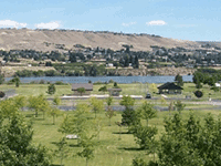
Where the Wenatchee River meets the Columbia, Wenatchee Confluence State Park preserves a landscape deeply sculpted by the Ice Age Floods. This junction of two river valleys created a natural widening in the flood corridor, allowing floodwaters to spread and deposit massive amounts of sediment as they temporarily lost velocity before being funneled back into the Columbia's narrow canyon downstream. The park was inundated to depths of hundreds of feet during the floods, and the flat terrain on which it sits is built from the gravel and sand deposited by those events. Today the park offers trails through riparian habitat along both rivers, with cottonwood groves and wetlands that have grown in the nutrient-rich flood deposits. The surrounding hillsides show flood scour lines and trimlines where vegetation changes abruptly at the elevation reached by the highest floodwaters. Along with Lincoln Rock and Daroga to the north, this park completes a trio of Columbia corridor sites where the floods' passage can be read in terraces, scour marks, and deposits. The confluence setting makes it especially scenic -- and geologically significant.
Open daily; summer hours 6:30 a.m. to dusk, winter hours 8 a.m. to dusk. Discover Pass required for day use. The park has 60 campsites (52 with full hookups) split between two waterfront loops; reservations recommended in peak season. Located where the Wenatchee River meets the Columbia River in Wenatchee, Washington.
The confluence sits within the Wenatchee reach of the Columbia, which carried some of the largest Missoula floods (depths near 1,000 ft / 305 m) before the Okanogan Lobe blocked the river north of here at 18.5–18 ka and forced subsequent floods down Moses and Grand coulees. After the Okanogan Lobe blocked the Columbia, flooding through the Wenatchee reach came from glacial Lake Columbia, not Lake Missoula. Boulders up to ~40 ft in diameter and ice-rafted erratics composed of granite and metamorphic rock foreign to the basalt valley are stranded across hillsides at elevations up to ~1,200 ft above the modern river, the Wenatchee Valley is one of the densest erratic fields documented anywhere on the flood path. The state park itself sits on the flood-deposited gravel and silt valley fill.
The Balbas et al. (2017) 10Be ages from regional erratics anchor the Wenatchee chronology; flooding through the reach predates 18 ka (pre-Okanogan blockage) and post-15.6 ka (Lake Columbia floods after Upper Grand Coulee opened). No new Wenatchee-specific dates published since.
The Wenatchee Valley Erratics Chapter, the first IAFI chapter, founded in 2001, uses the Wenatchee Valley as its core territory and is named for the local erratic field. The chapter meets at the Wenatchee Valley Museum and runs regular field trips that pass through or stop in the park.
Best April through October for the trail and water access. The park is the gateway to the 10-mile Apple Capital Loop Trail (Washington's longest loop trail), giving foot or bike access to flood-deposited terraces and the river edge.
Flood-extent overlay shows the maximum reach of the Missoula Floods.
The site in its place along the flood path, with the maximum flood extent drawn over the modern map.
View on the interactive map Searchable sites · 360° trails · flood reconstruction