 Washington
Washington
Washington
Rising 3,612 feet above the rolling wheat fields of the Palouse, Steptoe Butte is a quartzite island of ancient rock -- 400 million years older than the basalt that surrounds it -- that has given its name to an entire geological concept:...
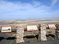
Rising 3,612 feet above the rolling wheat fields of the Palouse, Steptoe Butte is a quartzite island of ancient rock -- 400 million years older than the basalt that surrounds it -- that has given its name to an entire geological concept: the 'steptoe,' a hill of older rock protruding through younger lava flows. The butte survived because its hard quartzite resisted both the Columbia River basalt flows that buried the surrounding landscape 15 million years ago and the Missoula Floods that scoured the region 15,000 years ago. From the summit, accessible by a paved road, the 360-degree view is one of the finest in eastern Washington: the undulating Palouse Hills stretch to every horizon, their rich loess soils deposited by windstorms during the ice ages. On clear days you can see the scabland channels cutting through the Palouse to the west, where the floods ripped through the wheat country. The butte itself was an island during the floods, its summit above the waterline while the surrounding landscape was submerged. At sunset, the Palouse Hills glow gold and the flood channels cast long shadows -- a view that makes the ice age feel like yesterday.
Steptoe Butte State Park is a 168-acre heritage site north of Colfax, Washington, in Whitman County. It is open daily for day use; a Discover Pass is required. A paved road spirals to the 3,612-foot summit, which is a popular sunrise/sunset spot for photographers shooting the Palouse hills. No camping; restrooms and picnic sites only.
Steptoe Butte's relevance to the floods is indirect but significant, and the connection is to the post-flood loess, not to flood erosion. The butte is a 400-million-year-old quartzite knob that protrudes above the 15-million-year-old Columbia River Basalts; it gave geologists the term "steptoe" for any older bedrock projecting through younger lava. After the Missoula floods stripped vast areas of the Channeled Scabland, glacial-outwash silts and dust from the deflating outwash plains were blown southeast by prevailing winds and accumulated as loess to depths exceeding 200 feet across the Palouse. That loess produced the rolling hills and world-class agricultural soil visible from the summit. Steptoe Butte itself stood above both the basalt floods of the Miocene and the meltwater floods of the Pleistocene, the landscape around it is the byproduct of the floods, not the floods themselves.
Designated a National Natural Landmark in 1966. Subsurface geology continues to be reinterpreted with Palouse loess studies; Balbas et al. (2017) and follow-on cosmogenic work refined the timing of the basalt-stripping flood pulses that supplied loess sediment.
The Palouse Falls Chapter of IAFI covers Whitman County and uses Steptoe Butte as a summit overlook for interpreting the Palouse. No dedicated panel located on-site.
Spring (April–June) for wildflowers and the greenest hills; harvest season (August–September) for the golden Palouse photographs the area is famous for. Drive to the summit; viewing benches and short loops at the top.
Flood-extent overlay shows the maximum reach of the Missoula Floods.
The site in its place along the flood path, with the maximum flood extent drawn over the modern map.
View on the interactive map Searchable sites · 360° trails · flood reconstruction