 Washington
Washington
Washington
At Spring Creek Hatchery in the Columbia Gorge, the Missoula Floods reached an estimated 900 feet above modern sea level -- meaning the water column above this site was deeper than the height of a 70-story skyscraper. The gorge acted as a...
At Spring Creek Hatchery in the Columbia Gorge, the Missoula Floods reached an estimated 900 feet above modern sea level -- meaning the water column above this site was deeper than the height of a 70-story skyscraper. The gorge acted as a funnel, concentrating the floodwaters into a narrow canyon that amplified their depth and velocity. At peak flow, an estimated 386 million cubic feet per second of water surged through the gorge here, carving the canyon walls deeper and wider with each successive flood event. The hatchery today raises salmon in the same gorge that was once a raging torrent carrying icebergs, boulders, and entire forests. The basalt walls visible from the park show scour marks and high-water erosion lines hundreds of feet above the modern river level, physical evidence of the floodwaters' staggering depth. This site powerfully illustrates the gorge's role as the floods' final gauntlet: by the time floodwaters reached this narrow stretch, they had been squeezed from a 200-mile-wide flood plain into a canyon just a mile wide, concentrating their energy to extraordinary levels.
Spring Creek Hatchery State Park is a 10-acre day-use park in Skamania County, Washington, on the Columbia River across from Hood River, Oregon. It offers approximately 150 parking spaces, primitive picnicking, and no potable water or trash service (pack out what you pack in). A Discover Pass is required. The adjacent Spring Creek National Fish Hatchery, run by USFWS, is open separately and offers self-guided tours.
The Ice Age Floods relevance here is geographic and contextual rather than featured. The Columbia River Gorge in this stretch was the chokepoint that funneled every Missoula flood to the Pacific; floodwaters here briefly reached depths exceeding 1,000 feet, scouring basalt walls and stripping unconsolidated cover. The Gorge form visible from the park, vertical basalt walls and a wide, water-cut valley, reflects both 17- to 6-million-year-old Columbia River Basalt Group flows and Pleistocene flood erosion superimposed on them. The park itself does not have a distinctive flood landform; visitors come for water recreation and gorge views, with the geologic story interpreted more thoroughly upriver at the Columbia Gorge Discovery Center and downriver at Crown Point.
No park-specific geologic research located. Regional Gorge-flood work continues under the USGS Missoula and Bonneville flood review (O'Connor and Baker, 2020).
No formal IAFI panel or partnership at the hatchery. The Columbia River Gorge Chapter covers this region and references the Gorge generally rather than this specific site.
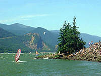
Best visited March through October; the location is famed among advanced windsurfers and kiteboarders for high winds and heavy whitecap waves. For Ice Age Floods context, pair a stop here with the Columbia Gorge Discovery Center in The Dalles.
Flood-extent overlay shows the maximum reach of the Missoula Floods.
The site in its place along the flood path, with the maximum flood extent drawn over the modern map.
View on the interactive map Searchable sites · 360° trails · flood reconstruction