 Washington
Washington
Washington
Massive columns of basalt up to 100 feet tall stand like ruined pillars of an ancient temple along the walls of Potholes Coulee, carved when the Missoula Floods cascaded westward from the Quincy Basin toward the Columbia River. The...
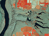
Massive columns of basalt up to 100 feet tall stand like ruined pillars of an ancient temple along the walls of Potholes Coulee, carved when the Missoula Floods cascaded westward from the Quincy Basin toward the Columbia River. The floodwaters poured over the edge of the basin in a temporary waterfall that rivaled Niagara in height, eroding backward through the basalt to create this dramatic coulee -- a dry canyon that once carried more water than any river on Earth today. The coulee's walls expose the distinctive columnar jointing of Columbia River basalt in spectacular cross-section, with individual columns fractured and displaced by the hydraulic forces. At the base of the coulee, enormous basalt blocks -- some the size of houses -- were ripped from the canyon walls and tumbled downstream by the flood currents. The coulee terminates at the Columbia River, where the floods carved a massive alcove into the gorge wall. Hiking through Potholes Coulee is like walking through a geological cathedral, with basalt columns rising on either side and the scale of destruction visible in every fractured surface.
Public access is via the Quincy Lakes Unit of the Columbia Basin Wildlife Area (WDFW); a Washington Discover Pass is required. The Ancient Lakes Trail (4–5 miles round trip, easy) and Dusty Lake spur descend into the coulee from the rim trailhead off White Trail Road near George, WA. Open year-round; spring and fall are best because the basin gets very hot in summer.
Potholes Coulee is a horseshoe-shaped recessional cataract on the western rim of the Quincy Basin, eroded headward as Missoula floodwaters overtopped Evergreen Ridge and plunged westward into the Columbia River valley. The flood surface rose to roughly 1,425 feet, overtopping low divides at Frenchman, Crater, and Potholes coulees and excavating all three. Features inside Potholes Coulee include the recessional headwall, giant current ripples on the floor, rock basins (the "potholes"), basalt pinnacles, and elongate streamlined bars. Ancient Lakes and Dusty Lake occupy plunge-pool and basin depressions left by the receding cataracts.
Lillquist's CWU field-trip guide (Ellensburg Chapter) is the standard interpretive reference. The 2020 USGS/Waitt review updates the regional flood chronology; no new site-specific peer-reviewed work since.
Covered by the IAFI Ellensburg Chapter and the Lower Grand Coulee Chapter. Routinely on IAFI field-trip itineraries.
Best in spring (March–May) when wildflowers bloom and temperatures are mild. The Ancient Lakes Trail is the standard introduction; experienced hikers can explore the upper cataract bench. No shade or water, bring both.
Flood-extent overlay shows the maximum reach of the Missoula Floods.
The site in its place along the flood path, with the maximum flood extent drawn over the modern map.
View on the interactive map Searchable sites · 360° trails · flood reconstruction