 Washington
Washington
Washington
This site commemorates the research of Dr. Ralph Haugerud and other scientists investigating how the southern margin of the Cordilleran Ice Sheet -- the massive glacial complex that spawned both the ice dams and the floods -- met its end....
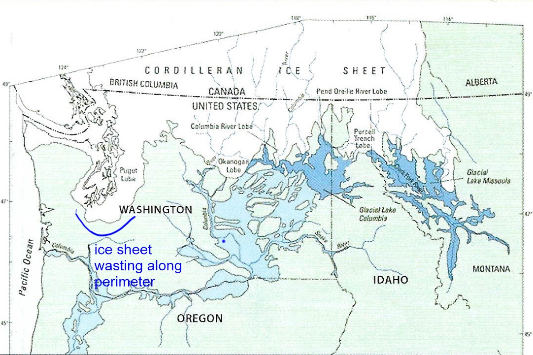
This site commemorates the research of Dr. Ralph Haugerud and other scientists investigating how the southern margin of the Cordilleran Ice Sheet -- the massive glacial complex that spawned both the ice dams and the floods -- met its end. The death of an ice sheet is a slow and complex process, and understanding how the Cordilleran Ice Sheet retreated is critical to understanding the timing and sequence of the Missoula Floods. The ice sheet's advance created the Okanogan and Purcell Trench lobes that blocked rivers and formed the glacial lakes, and its retreat determined when the flooding finally stopped. Research in this area has revealed that the ice margin oscillated back and forth multiple times during deglaciation, with each advance potentially creating new ice dams and new flood events. The southern Cordilleran Ice Sheet at its maximum covered much of Washington, Idaho, and Montana with ice thousands of feet thick. Understanding its collapse helps explain why the floods happened when they did, why they repeated dozens of times, and why they eventually stopped -- questions that remain at the frontier of ice age research.
This is the title of a lecture by Dr. Ralph A. Haugerud (USGS, retired) delivered to the IAFI Puget Lobe Chapter on March 18, 2024, not a physical site. The presentation lives as a posted talk announcement on iafi.org and was recorded for the chapter's archives.
The lecture covers the late-glacial retreat (≈15 ka) of the southern Cordilleran Ice Sheet, with an emphasis on the very different mechanisms east and west of the Cascade crest. West of the Cascades the Puget Lobe collapsed against sea-level forcing; east of the Cascades the Okanogan and Purcell lobes governed the Missoula Flood routing through Grand Coulee and the northwestern Columbia valley. Haugerud's framing matters for the floods story because flood pathways changed as the lobes retreated, Balbas et al. (2017) and follow-on work tie specific flood ages to whether the Okanogan lobe was blocking or had retreated from the Columbia valley.
Haugerud's USGS work and Booth et al.'s long-running record on Cordilleran ice-sheet retreat (UW) are the foundational references; recent additions include offshore-sediment work by Hatfield, Praetorius, and others on Cascadia margin cores that record the deglacial outburst-flood signal (AGU 2023).
Direct IAFI product, Puget Lobe Chapter program.
Not applicable; this is an essay/lecture, not a place. Visitors interested in the Cordilleran-ice-sheet story should visit Discovery Park in Seattle (referenced in the related IAFI Puget Sound article) where the bluffs expose the advance–retreat sequence.
Flood-extent overlay shows the maximum reach of the Missoula Floods.
The site in its place along the flood path, with the maximum flood extent drawn over the modern map.
View on the interactive map Searchable sites · 360° trails · flood reconstruction