 Washington
Washington
Washington
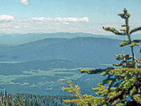
From the summit of Mount Spokane, at 5,883 feet the highest point in Spokane County, you look down on the exact route of the initial Ice Age Floods outburst. The view south and east reveals the Rathdrum Prairie and Spokane Valley -- the...
From the summit of Mount Spokane, at 5,883 feet the highest point in Spokane County, you look down on the exact route of the initial Ice Age Floods outburst. The view south and east reveals the Rathdrum Prairie and Spokane Valley -- the corridor through which 500 cubic miles of water from Glacial Lake Missoula first erupted when the Purcell Trench ice dam failed. The floodwaters roared across the Rathdrum Prairie at speeds estimated at 65 miles per hour, filling the Spokane Valley wall to wall before surging westward across the Columbia Plateau. From this elevation, the flood's path is strikingly visible: the broad, flat prairie stretching toward Idaho where the ice dam once stood, the narrowing valley where the waters accelerated into Spokane, and the scabland channels radiating outward to the southwest. The mountain itself stood well above the flood's reach, making it one of the best vantage points from which to comprehend the event's geographic scale. Mount Spokane State Park offers year-round recreation from skiing to hiking, but the real draw for flood enthusiasts is this bird's-eye view of ground zero.
Open year-round, day-use and overnight. Discover Pass required for day use ($10/$30). Located 30 miles northeast of Spokane, Washington, off SR 206. 13,919 acres, summit elevation 5,883 feet (highest peak in Spokane County). Summit road open seasonally (typically late May–October); winter access for skiing/snowshoeing.
Mount Spokane is a secondary flood site, it is above the inundation footprint rather than directly within it. The mountain is a Selkirk-affiliated granitic intrusion that stood as bedrock high ground while Missoula floodwaters surged south through the Rathdrum Prairie and Spokane Valley far below (peak flood elevations around Spokane were roughly 2,400 feet asl). The summit view south and west takes in the Channeled Scablands landscape: Long Lake gorge, the Spokane Valley flood channel, the Cheney-Palouse tract, and on a clear day, the lobes of the Cordilleran Ice Sheet's southern terminus. The mountain itself does not preserve direct flood-scour features; its value on the trail is panoramic context for understanding flood pathways through the Spokane area.
No site-specific peer-reviewed flood research. The Rathdrum Prairie aquifer (which the floods built by depositing coarse gravel through the Spokane Valley) is the focus of ongoing hydrogeologic studies (e.g., Washington State University Spokane).
The Cheney-Spokane Chapter is the IAFI affiliation; the chapter sometimes uses the summit as a context viewpoint on driving tours. No interpretive panel at the park is dedicated to the floods.
Best late May–October for summit road access. Vista House at the summit is open seasonally and has region maps. Pair with Riverside State Park's Bowl & Pitcher (flood-deposited boulders) and the Palisades Conservation Area (better direct flood-scour exposure) for a fuller Spokane-area flood day.
Flood-extent overlay shows the maximum reach of the Missoula Floods.
The site in its place along the flood path, with the maximum flood extent drawn over the modern map.
View on the interactive map Searchable sites · 360° trails · flood reconstruction