 Washington
Washington
Washington
The broad bench on which Maryhill State Park sits was carved by the Missoula Floods as they surged through the Columbia River Gorge with enough force to reshape solid basalt hillsides. Floodwaters at this location reached staggering...
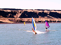
The broad bench on which Maryhill State Park sits was carved by the Missoula Floods as they surged through the Columbia River Gorge with enough force to reshape solid basalt hillsides. Floodwaters at this location reached staggering depths, scouring a wide terrace into the canyon wall that today provides the park's flat camping and recreation areas above the river. The park sits near the eastern entrance to the gorge, where the floods transitioned from the wide Pasco Basin into the increasingly constricted canyon -- accelerating as the walls closed in and their destructive power intensified. Across the river, the eccentric Maryhill Museum houses an unexpected collection of Rodin sculptures and a full-scale replica of Stonehenge, built as a war memorial by railroad magnate Sam Hill. The juxtaposition is surreal: ancient flood-carved basalt terraces overlooking a concrete Stonehenge, with the Columbia Gorge stretching to the horizon. The park's location makes it an excellent base camp for exploring the eastern gorge's flood features, from Horsethief Butte to Rowena Crest, all within a short drive along the river.
Open year-round; Discover Pass required for day use. 99-acre park on the north bank of the Columbia River in Goldendale, Washington, just south of US 97 and the Sam Hill Memorial Bridge to Oregon. Standard Washington State Parks campsites, boat launch, swimming.
Maryhill sits at the eastern end of the Columbia River Gorge, at the entrance to a 60-mile-long basalt canyon that the Missoula Floods scoured deeply between 18.2 and 14 ka. The park's south-facing bluffs show the layer-cake stratigraphy of Columbia River Basalt flows (Grande Ronde and Wanapum Basalts), with flood-scour features cleanest just west of the park. Floodwaters here were constrained between basalt walls, the gorge narrows from 5 miles wide at the Tri-Cities (Wallula Gap) to about 1 mile wide at Maryhill, accelerating flow and producing the steep dry channels visible on both sides of the river. Slack-water silt deposits ("Touchet Beds") are exposed in road cuts immediately east of the park; the famous full-size Stonehenge replica on the bluff above the park (built by Sam Hill in 1929) sits on flood-stripped basalt. The Maryhill Museum, also nearby, holds Native artifacts but does not currently feature an Ice Age Floods exhibit.
No site-specific updates since the Balbas et al. (2017) and Waitt and O'Connor (2021) syntheses.
The Lower Columbia Chapter covers Maryhill. NPS/IAFI interpretive panels are in place at the park. The Columbia Gorge Discovery Center 30 miles west in The Dalles has fuller flood interpretation than the park itself.
Best March through October; summer is hot and windy. Combine with the Stonehenge replica, Maryhill Museum of Art, and a drive west into the gorge through Wishram and the Dalles for cleaner basalt scour exposures.
Flood-extent overlay shows the maximum reach of the Missoula Floods.
The site in its place along the flood path, with the maximum flood extent drawn over the modern map.
View on the interactive map Searchable sites · 360° trails · flood reconstruction