 Washington
Washington
Washington
Named for a basalt formation said to resemble Abraham Lincoln's profile, Lincoln Rock State Park sits along a stretch of the Columbia River that was inundated by the Missoula Floods to depths of several hundred feet. The floods surged down...
Named for a basalt formation said to resemble Abraham Lincoln's profile, Lincoln Rock State Park sits along a stretch of the Columbia River that was inundated by the Missoula Floods to depths of several hundred feet. The floods surged down the Columbia corridor here with enough force to strip vegetation, soil, and loose rock from the canyon walls, leaving the polished basalt surfaces visible today. This stretch of river, between Wenatchee and Chelan, was one of the primary flood conduits where water from both Glacial Lake Columbia and Glacial Lake Missoula converged, creating depths that would have submerged the park's highest points. The rocky terraces and benches along the shoreline are flood-deposited features, built from the enormous sediment loads carried by the floodwaters. Along with neighboring Daroga and Wenatchee Confluence State Parks, Lincoln Rock preserves a section of the Columbia corridor where the full power of the floods can be read in the landscape. The park's swimming beach and campground sit on sediments deposited by waters that once flowed at speeds exceeding 60 miles per hour.
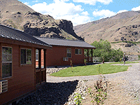
Open year-round; 86-acre camping park on the east side of Lake Entiat (Columbia River reservoir behind Rocky Reach Dam), 7 miles north of Wenatchee. Discover Pass required for day use; standard Washington State Parks camping fees. Boat launches, swimming beach, deluxe cabins.
Lincoln Rock is a secondary flood site. The Missoula Floods did flow through the Columbia River valley here, but they passed through a relatively constrained gorge rather than dispersing across a plateau, the park's surface features are dominated by post-glacial Columbia River terraces and modern reservoir flooding rather than direct flood-scour evidence. The more diagnostic floods feature in the area is the Withrow Moraine on the Waterville Plateau immediately east of the park, which marks the southern terminus of the Okanogan Lobe at roughly 17 ka, the same advancing lobe that diverted Missoula floodwater into Upper Grand Coulee. Ice-rafted erratics from Missoula Floods occur on Wenatchee Valley benches up to about 1,250 feet asl. The "Lincoln Rock" namesake basalt formation across the reservoir is a post-eruption erosional remnant of Columbia River Basalt, not a flood feature.
No site-specific peer-reviewed updates. The Withrow Moraine and Wenatchee-area ice-rafted erratic inventory (Wenatchee Naturalist Society, ongoing) remain the most active local research streams.
The Wenatchee Valley Erratics Chapter is based locally and is the most appropriate IAFI affiliation. No dedicated chapter or interpretive panel at the park itself.
Best May through September. The park is set up for camping and boating rather than geology; the actual Ice Age Floods learning is better done at the Wenatchee Valley Erratics chapter's self-guided erratic tour or on the Waterville Plateau drive east of US 97 (toward Withrow Moraine).
Flood-extent overlay shows the maximum reach of the Missoula Floods.
The site in its place along the flood path, with the maximum flood extent drawn over the modern map.
View on the interactive map Searchable sites · 360° trails · flood reconstruction