 Montana
Montana
Montana
At its peak, Glacial Lake Missoula held 500 cubic miles of water -- as much as Lake Erie and Lake Ontario combined -- impounded behind a wall of ice 2,000 feet thick that blocked the Clark Fork River in northern Idaho. The lake stretched...
At its peak, Glacial Lake Missoula held 500 cubic miles of water -- as much as Lake Erie and Lake Ontario combined -- impounded behind a wall of ice 2,000 feet thick that blocked the Clark Fork River in northern Idaho. The lake stretched across 3,000 square miles of western Montana, filling the Missoula, Bitterroot, Mission, Jocko, and Little Bitterroot valleys to depths that would have submerged skyscrapers. When the ice dam inevitably failed -- an event that happened 40 to 100 times over roughly 4,000 years beginning around 17,000 years ago -- the lake's entire contents emptied in as little as 48 hours, releasing a torrent that reshaped the landscape from Montana to the Pacific Ocean. The estimated peak discharge rate was 10 cubic miles per hour, a volume of water so staggering that it carved the Channeled Scablands, created the world's largest waterfall at Dry Falls, and deposited sediment fans on the Pacific continental shelf. Designated a National Natural Landmark, this site 12 miles north of Perma preserves the giant ripple marks and flood bars that prove this was the source of the most catastrophic floods ever documented on Earth.
The Glacial Lake Missoula NNL is centered on the Camas Prairie ripples, about 110 km (68 miles) northwest of Missoula and 12 miles north of Perma, Montana, in the north end of Camas Prairie Valley. Access is via Montana Highway 28 with a designated turnout and interpretive signage; the ripples themselves are on private ranchland and are best viewed from the highway. Year-round; the angle of low morning or evening sun is required to read the ripples on the ground.
The Camas Prairie ripples are the largest current-formed bedforms ever documented on Earth. Individual ridges are 15–50 ft high, 100–250 ft wide, and 300 ft to half a mile long, arranged in arcuate trains across the prairie floor. They formed at the bottom of Glacial Lake Missoula during catastrophic dam-failure drainage events: when the lake drained, north-arm water surged through Camas Prairie at flow depths of hundreds of feet, and the floor-level current shaped the giant ripples like ordinary stream ripples scaled up by three orders of magnitude. The NNL recognizes them as the type locality for giant flood ripples.
The Balbas et al. 2017 chronology constrains repeated drainage events between 18.2 ± 1.5 ka and 14.7 ± 1.2 ka. Larry Smith's 2021 Montana Tech field guide treats Camas Prairie in detail. No major reinterpretation since 2017.
The Glacial Lake Missoula chapter is the lead IAFI presence; the NNL is one of the chapter's signature interpretive stops.
Best viewed in low-angle morning or evening light, fall through spring. Aerial views are far more legible than ground views; if a flight or drone view is available, take it. The MT-28 turnout is the only legal stop.
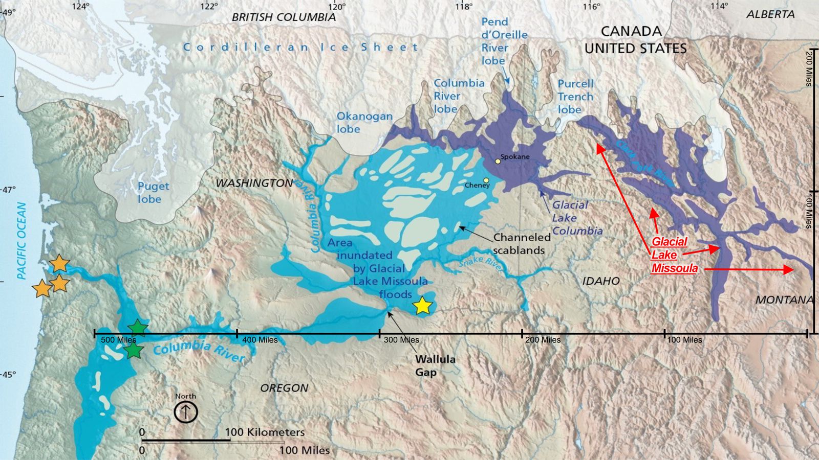
Flood-extent overlay shows the maximum reach of the Missoula Floods.
The site in its place along the flood path, with the maximum flood extent drawn over the modern map.
View on the interactive map Searchable sites · 360° trails · flood reconstruction