 Washington
Washington
Washington
Frenchman Coulee is one of the most dramatic and accessible flood-carved canyons in the Columbia Basin, where Ice Age Floodwaters cascaded off the Columbia Plateau in a temporary waterfall that rivaled Niagara before carving this deep...
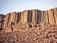
Frenchman Coulee is one of the most dramatic and accessible flood-carved canyons in the Columbia Basin, where Ice Age Floodwaters cascaded off the Columbia Plateau in a temporary waterfall that rivaled Niagara before carving this deep alcove into the basalt. Like neighboring Potholes Coulee to the north, floodwaters flowed westward from the Quincy Basin toward the Columbia River, but at Frenchman Coulee the results are especially photogenic: towering columnar basalt walls, a massive plunge pool amphitheater, and scattered house-sized basalt blocks torn from the canyon rim. The basalt columns here are popular with rock climbers, who scale the same geological features that the floods ripped apart. The coulee terminates at the Columbia River near Vantage, and the view down the canyon toward the river traces the exact path the floodwaters took. The Feathers, a cluster of basalt pillars standing like sentinels at the canyon entrance, are a landmark visible from Interstate 90. Frenchman Coulee is easily accessible from the Vantage Highway, making it one of the most rewarding quick stops on the Ice Age Floods trail -- a place where the geological violence is written in every crack and column.
Frenchman Coulee is on Washington DNR and Bureau of Reclamation land off I-90 at Vantage, exit 143 (Silica Road), Grant County. Open year-round; popular with rock climbers. No entry fee. Sagecliffe Resort sits on the south rim. Primitive camping and dispersed parking; pit toilets only.
Frenchman Coulee is a dual-channel cataract system (Frenchman Coulee and Echo Basin), separated by a remnant basalt blade, the "Feathers", whose tall columnar joints are the iconic climbing terrain. The coulee carved headward more than 2 miles as Missoula floodwaters spilling out of the Quincy Basin cascaded over a 600-ft drop into the present Columbia River channel. Columnar basalt, jointed at hexagonal scales, was unusually vulnerable to plucking by high-velocity flow, and the coulee's recessional retreat exploited that vulnerability. A seasonal waterfall flows at the head of the coulee in spring.
No new geomorphic interpretation published since 2017. No updates found since the Balbas et al. 2017 chronology.
Within the Wenatchee chapter's territory; appears in regional field-trip itineraries.
Spring (March–May) for the waterfall and wildflowers; fall for climbing-friendly temperatures. Summer is hot and exposed. The rim drives along Old Vantage Highway give the best overview.
Flood-extent overlay shows the maximum reach of the Missoula Floods.
The site in its place along the flood path, with the maximum flood extent drawn over the modern map.
View on the interactive map Searchable sites · 360° trails · flood reconstruction