 Montana
Montana
Montana
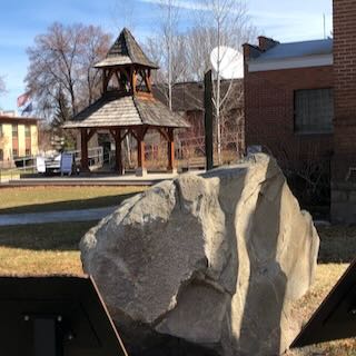
An 8-ton glacial erratic that spent 13,000 years on a Bitterroot Valley ranch has been relocated to the Ravalli County Museum in Hamilton, Montana, where it now serves as the centerpiece of an outdoor kiosk exhibit telling the story of...
An 8-ton glacial erratic that spent 13,000 years on a Bitterroot Valley ranch has been relocated to the Ravalli County Museum in Hamilton, Montana, where it now serves as the centerpiece of an outdoor kiosk exhibit telling the story of Glacial Lake Missoula. This boulder was dropped by a melting iceberg that floated across the lake's surface when water filled the Bitterroot Valley to depths of hundreds of feet. The erratic's rock type traces back to the northern Idaho mountains, hundreds of miles from where it came to rest -- irrefutable proof of the lake's reach into this southern Montana valley. The Ravalli County Museum exhibit includes interpretive panels explaining how these boulders were carried by icebergs calving from mountain glaciers into the lake, then drifting south on currents until the ice melted and dropped its cargo. The exhibit connects this single boulder to the broader story of Glacial Lake Missoula and the catastrophic floods that drained it. Touch this rock and you are touching a traveler that rode an iceberg across an inland sea that no longer exists.
The Bitterroot Valley glacial erratics, most notably the Lone Rock School erratic (Stevensville area) and the Rome Lane erratic, sit on or beside public road shoulders in private agricultural land in Ravalli County, Montana. Both are roadside-accessible with no formal facilities. Year-round.
These are not Missoula-flood deposits in the downstream sense. They were ice-rafted into the Bitterroot Valley by icebergs floating on the highest stands of Glacial Lake Missoula itself, when lake water backed south up the Bitterroot Valley as far as Sula, roughly 286 miles from the lake's main body near Missoula. The Rome Lane erratic (~13 metric tons; 47" × 117" × 96") is a quartz-monzonite block whose source is the Bitterroot Mountains 5–20 miles to the west; it was lifted off a glacial-margin source, frozen into a lake-surface iceberg, drifted south, and grounded at lake-bottom elevation when the iceberg melted. Lone Rock and Rome Lane mark the south-arm shoreline of the last major lake stand, around 13–15 ka in the older literature and within the 18.2–14 ka megaflood window per Balbas et al. 2017.
Ravalli County Museum's "Glaciers in the Bitterroot" exhibit (active 2024–) provides accessible synthesis but does not publish new chronology. The Larry Smith 2021 field guide treats Bitterroot erratics. No updates found since the 2017 chronological framework.
Glacial Lake Missoula chapter (Montana) interprets the Bitterroot erratics and runs field trips. Ravalli County Museum in Hamilton hosts a related public exhibit.
Year-round. Combine with the Ravalli County Museum exhibit in Hamilton for context. The erratics themselves are short roadside stops.
Flood-extent overlay shows the maximum reach of the Missoula Floods.
The site in its place along the flood path, with the maximum flood extent drawn over the modern map.
View on the interactive map Searchable sites · 360° trails · flood reconstruction