 Washington
Washington
Washington
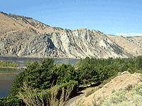
Daroga State Park sits on a terrace along the Columbia River that was built and shaped by the Ice Age Floods as they surged down the Columbia corridor. The floods inundated this area along with neighboring Lincoln Rock and Wenatchee...
Daroga State Park sits on a terrace along the Columbia River that was built and shaped by the Ice Age Floods as they surged down the Columbia corridor. The floods inundated this area along with neighboring Lincoln Rock and Wenatchee Confluence State Parks, leaving behind a landscape of scoured bedrock, gravel terraces, and flood-deposited sediments. This stretch of the Columbia between the Chelan area and Wenatchee was one of the primary flood conduits, carrying water from both Glacial Lake Columbia (impounded by the Okanogan ice lobe to the north) and the enormous Missoula Flood pulses coming from the east. The terraced benches on which the park is built are composed of flood gravels -- rounded cobbles and boulders sorted and deposited as floodwaters lost velocity in the wider sections of the valley. The park's orchard-dotted surroundings owe their fertile soil to these same flood deposits. Camping at Daroga, you sleep on a bed of Ice Age Floods gravel, and the Columbia flowing past is a gentle echo of the torrent that once filled this valley wall to wall.
Daroga State Park is on the Columbia River off US-97 between Wenatchee and Chelan, near Orondo. Open daily 6:30 a.m. to dusk; closed November 1–March 31. Camping is by reservation May 15–September 15. A Discover Pass ($10 day / $30 annual) is required for day use; camping is $12/night plus $8 reservation fee.
Daroga is a secondary Ice Age Floods site. It sits along the reach of the Columbia River that carried meltwater and Missoula floodwaters when the Okanogan lobe alternately advanced and retreated. The terrace landscape and exposed Columbia River Basalt cliffs around the park record erosion by flood-stage Columbia flows, including the 18.2 ka western-route flood (per Balbas et al. 2017) before the Okanogan-lobe ice diverted later floods east through the Grand Coulee. The park itself does not preserve a single signature flood landform, its value is as a scenic stop along the northwestern flood pathway.
No site-specific geologic research published since 2017. No updates found since the Balbas et al. 2017 framework.
No dedicated IAFI chapter, panel, or named partnership at the park. Daroga appears in Washington State Parks' "Ice Age Floods" thematic park list.
April through October for camping; year-round for day use. Best for travelers crossing the Columbia between Wenatchee and Lake Chelan who want a swim, picnic, or overnight stop.
Flood-extent overlay shows the maximum reach of the Missoula Floods.
The site in its place along the flood path, with the maximum flood extent drawn over the modern map.
View on the interactive map Searchable sites · 360° trails · flood reconstruction