 Washington
Washington
Washington
Stretching 130 miles along an abandoned railroad grade, the Columbia Plateau Trail is the longest rails-to-trails conversion in Washington state and traverses the heart of the Channeled Scablands. The northern end near Cheney places hikers...
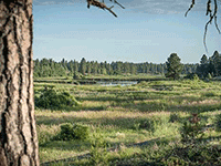
Stretching 130 miles along an abandoned railroad grade, the Columbia Plateau Trail is the longest rails-to-trails conversion in Washington state and traverses the heart of the Channeled Scablands. The northern end near Cheney places hikers and bikers directly in the Cheney-Palouse scabland tract, where the Missoula Floods carved a braided network of channels through millions of years of basalt bedrock in a matter of days. The trail follows the flood's path across terrain that looks like it was clawed by a giant hand: deep channels separated by sharp-edged basalt ridges, pothole lakes filling scour depressions, and scattered glacial erratics dropped by melting icebergs. Walking or cycling this trail, you traverse one of the most complete sequences of flood-carved terrain anywhere, from the initial scabland channels near Cheney through progressively larger flood features as you head south toward the Columbia River. The flat railroad grade makes the trail accessible to all abilities while passing through some of the most dramatic geology in the Pacific Northwest. This is perhaps the best way to experience the scablands at a human pace.
The Columbia Plateau Trail State Park is a 130-mile rail-trail along the abandoned Spokane, Portland and Seattle Railway corridor between Fish Lake (just outside Cheney, Washington) and the Columbia–Snake confluence at Pasco. The north end runs from Fish Lake Trailhead Regional Park to Cheney as a 3.75-mile paved segment, then continues south unpaved. A Discover Pass is required at staging areas. The trail passes through Turnbull National Wildlife Refuge for about 4.75 miles, which is a fee-managed refuge. Open year-round; the paved segment is also used for cross-country skiing and snowshoeing in winter.
The north end of the Columbia Plateau Trail crosses the eastern fringe of the Channeled Scabland, the landscape carved by Missoula flood waters that diverted south after being blocked by the Okanogan Lobe and Glacial Lake Columbia. Around Cheney and Fish Lake, the trail crosses flood-scoured basalt benches, drainless coulees, and the headward eroded scarps of the scabland's eastern tract. The Cheney–Spokane area was on the inflow side: Lake Missoula's outburst waters spilled across the Rathdrum Prairie and through the Spokane Valley into the scabland tract that this trail traverses.
Balbas et al. (2017) places the largest floods at ~18.2 ± 1.5 ka and the last Missoula floods at ~14.7 ± 1.2 ka via 10Be cosmogenic dating. The O'Connor et al. (2020) review remains the regional synthesis.
The IAFI Cheney-Spokane Chapter is the responsible chapter and is one of IAFI's most active chapters in field-trip programming. Eastern Washington University (Cheney) hosts the IAFI's digital records archive.
Spring (March–May) and fall (September–October) are best; summer heat and limited shade can be punishing. The Fish Lake to Cheney paved segment is the most family-friendly entry; the unpaved miles south of Cheney are best by bike or horse. Pair with Turnbull NWR for wildlife and the Cheney-area scabland geology overlooks.
Flood-extent overlay shows the maximum reach of the Missoula Floods.
The site in its place along the flood path, with the maximum flood extent drawn over the modern map.
View on the interactive map Searchable sites · 360° trails · flood reconstruction