 Oregon
Oregon
Oregon
The Columbia Gorge Discovery Center in The Dalles, Oregon, occupies a 54-acre point of land at the eastern gateway to the Columbia Gorge, one of the oldest continuously occupied places in North America with over 11,000 years of human...
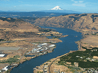
The Columbia Gorge Discovery Center in The Dalles, Oregon, occupies a 54-acre point of land at the eastern gateway to the Columbia Gorge, one of the oldest continuously occupied places in North America with over 11,000 years of human habitation. The 48,200-square-foot museum contains interactive exhibits on the gorge's creation, including a full-size Columbian mammoth, Ice Age Floods displays, Lewis and Clark exhibits, and a life-size wagon-raft exhibit showing pioneer crossings of the Columbia. The center sits just east of the Rowena Gap, where the topographical constriction of the gorge slowed the Missoula Floods and backed water upstream to form Glacial Lake Condon. At this site during peak flooding, the water transition from wide basin to narrow gorge created some of the most turbulent hydraulics along the entire flood path. Walking trails, scenic overlooks, and a pond on the grounds let visitors explore the landscape between exhibits. The Discovery Center is an excellent stop for families, and the combination of geological, cultural, and natural history makes it one of the most comprehensive interpretive sites on the entire Ice Age Floods trail.
The Columbia Gorge Discovery Center & Museum sits on 54 acres at 5000 Discovery Drive, The Dalles, Oregon. Open daily 9 a.m.–5 p.m. (closed major holidays). Admission charged (typically $11 adult; check current rates). Operated as the official interpretive center for the Columbia River Gorge National Scenic Area; 48,200 sq ft of exhibits including a Lewis and Clark gallery, a Native American basketry gallery, and the geology / Ice Age halls.
The Discovery Center's geology hall is one of the few formal museum installations dedicated to the Ice Age Floods story. Exhibits cover the formation of Glacial Lake Missoula, dam-failure mechanics, the carving of the Columbia Gorge, and the regional flood pathway, with a full-size 13-foot Columbian mammoth replica as the gallery centerpiece. The Center sits in the heart of the Gorge, roughly 50 miles east of Bonneville Dam, on the south flank of the corridor that channeled every Missoula flood toward the Pacific.
The exhibits reflect mid-2010s interpretation; no published curatorial update post-Balbas et al. (2017) is documented. Visitors should expect the 15-ka date sometimes used in older signage rather than the 18.2-ka anchor.
Strong. IAFI maintains a dedicated page on the Discovery Center and the Columbia River Gorge Chapter has regularly held presentations and programs in the Center's lecture facilities. The Center is one of the chapter's primary indoor venues.
Year-round. Allow 2–3 hours for full exhibits. Pair with the Columbia Gorge Interpretive Center (Stevenson, 35 miles west) for the Washington-side counterpart, and with a drive on the Historic Columbia River Highway through Multnomah Falls.
Ice Age Floods National Geologic Trail,Lewis & Clark National Historic Trail,Oregon National Historic Trail
The Columbia Gorge Discovery Center & Museumis located on a 54-acre point of land adjacent to the Columbia River and is the interpretive center for the Columbia River Gorge National Scenic Area.
This area includes one of the oldest continuously occupied places in North America (over 11,000 years) and parts of the Lewis and Clark and Oregon Trails.
On the grounds are walking trails, a pond, scenic overlooks, and historic artifacts.
The 48,200 square foot Discovery Center & Museum building contains interactive exhibits about the creation of the gorge; Ice Age animals, including a full-size Columbian mammoth; the Lewis & Clark Corps of Discovery; native peoples of the area; and a life-size exhibit featuring a wagon-raft braving the Columbia River’s current.
This is an excellent stop for families with children.
Allow several hours for your visit. Modest admission is charged.
Visit us atFacebook,Mastodonand ourYouTube Channel.
Ice Age Floods Institute is a 501(c)(3) tax-exempt non-profit EIN 91-1658221Donations and member fees may be tax deductible


Flood-extent overlay shows the maximum reach of the Missoula Floods.
The site in its place along the flood path, with the maximum flood extent drawn over the modern map.
View on the interactive map Searchable sites · 360° trails · flood reconstruction