 Washington
Washington
Washington
During the last ice age, the land at Bridgeport State Park lay buried beneath the advancing and retreating Okanogan Lobe of the Cordilleran Ice Sheet, a wall of ice thousands of feet thick that completely reshaped this stretch of the...
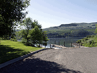
During the last ice age, the land at Bridgeport State Park lay buried beneath the advancing and retreating Okanogan Lobe of the Cordilleran Ice Sheet, a wall of ice thousands of feet thick that completely reshaped this stretch of the Columbia River. As the glacier retreated, it left behind a landscape of glacial debris, scoured bedrock, and the characteristic hummocky terrain visible throughout the park today. The ice lobe's advance blocked the Columbia River, creating Glacial Lake Columbia and diverting floodwaters southward to carve the Grand Coulee -- meaning the events at Bridgeport were directly responsible for some of the most dramatic flood features downstream. The park sits on the shores of Rufus Woods Lake, a reservoir formed by Chief Joseph Dam, and the surrounding basalt cliffs show the scour marks and polished surfaces left by both glacial ice and catastrophic flooding. Haystacks -- large basalt pillars sculpted by wind erosion in glacial sediments -- dot the landscape and are unique to this area. Bridgeport State Park is where the ice age story begins: the place where glaciers met the Columbia River and set in motion the chain of events that would reshape an entire region.
Bridgeport State Park is a 622-acre Washington State Park on Rufus Woods Lake (the reservoir behind Chief Joseph Dam), just east of Bridgeport. A Discover Pass ($10/day or $45/year) is required for vehicle access. Campers (34 sites; 20 with hookups) are exempt while overnighting. The park is open year-round.
Bridgeport sits inside the maximum reach of the Okanogan Lobe of the Cordilleran Ice Sheet. During the last glaciation, ice more than 1,000 feet thick covered today's park, plucking basalt out of the Columbia River canyon walls and carrying it along. When the ice halted and melted, the basalt blocks were left in place as the park's iconic "haystack rocks." Strictly speaking, these are ice-rafted erratics tied to the Okanogan Lobe rather than flood-rafted erratics, but the Okanogan ice dam was the impoundment that created Glacial Lake Columbia upstream and forced the Missoula floods south through Grand Coulee and the Channeled Scabland. The park is a key stop for understanding the upstream side of the flood-pathway puzzle.
A 2024 GSA Cordilleran Section abstract by Markham et al. on the glaciotectonics of the Okanogan Lobe and the Withrow Moraine refined the lobe's behavior at upper Moses Coulee, with implications for Glacial Lake Columbia drainage. No specific re-dating of Bridgeport haystacks since 2017.
Site is referenced in IAFI's "Ice Age Flood Pathways in the North-Central Washington Area" overview; no dedicated park page on iafi.org found, no IAFI chapter is geographically centered here (the nearest are Wenatchee Valley Erratics and Lower Grand Coulee).
April–October is best; winters are cold and windy. Haystack rocks are visible from the campground loop and short walking paths. Pair with Steamboat Rock State Park and Dry Falls on a Grand Coulee circuit.
Flood-extent overlay shows the maximum reach of the Missoula Floods.
The site in its place along the flood path, with the maximum flood extent drawn over the modern map.
View on the interactive map Searchable sites · 360° trails · flood reconstruction