 Washington
Washington
Washington
The second-largest freestanding monolith in the United States, Beacon Rock towers 848 feet above the Columbia River -- and every foot of exposed stone tells the story of two types of catastrophic geological events. Beacon Rock is a...
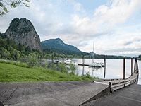
The second-largest freestanding monolith in the United States, Beacon Rock towers 848 feet above the Columbia River -- and every foot of exposed stone tells the story of two types of catastrophic geological events. Beacon Rock is a volcanic neck, the hardened magma core of an ancient Boring Lava Field volcano that erupted roughly 57,000 years ago. When the Missoula Floods roared through the Columbia Gorge, reaching estimated depths of 800 to 1,000 feet at this location, they stripped away the softer outer layers of the volcano like peeling an onion, leaving only the dense basalt core standing. Lewis and Clark noted the rock in 1805 and used it as a landmark indicating they were nearing tidewater. A remarkable trail of switchbacks and bridges, built by Henry Biddle in 1918, takes hikers to the summit in about a mile, offering views up and down the Gorge that make the flood's path viscerally clear. From the top, you can see both the narrow gorge upstream where the floods accelerated and the wider valley downstream where they began to spread out. Beacon Rock is where volcanic fire met glacial flood in a collision of forces that left one of the most recognizable landmarks in the Pacific Northwest.
Beacon Rock State Park, on Washington SR-14 east of Vancouver, is open year-round 8 a.m. to dusk. A Discover Pass ($10/day or $45/year) is required to park. The signature Beacon Rock Trail is 1.7 miles round trip with 574 feet of gain, switchbacking up the monolith on a 1915-era handrailed catwalk. The park also has roughly 13 miles of bike and hiker trails on Hardy Ridge and the Saddle.
Beacon Rock is the eroded basalt core of a roughly 57,000-year-old cinder cone in the Boring Volcanic Field. Missoula flood waters tearing through the Columbia Gorge stripped away the softer cinder, ash, and lava-flow surroundings and left the dense vent plug standing 848 feet above the river. The Gorge itself was scoured to its modern depth and shape over roughly 40 flood events ending around 14 ka, with peak Gorge discharges estimated at 5–15 million m³/s. The view from the summit looks straight down the flood-carved corridor that channeled every Missoula flood toward the Pacific.
No updates found since Balbas et al. (2017) and the O'Connor et al. (2020) review summarizing Gorge discharges and flood timing. Volcanic-age constraints on Beacon Rock itself are older than 2017 and have not been revised.
IAFI has a dedicated Beacon Rock page identifying it as a key flood-erosion landmark and includes it in Columbia River Gorge Chapter programming. No on-site interpretive panel attributed specifically to IAFI is documented, though the park's own historic signage acknowledges the flood erosion story.
Best March–November; the catwalk gets icy in winter. Plan 1–1.5 hours for the round-trip climb. Pair with Multnomah Falls and Crown Point on a Gorge geology tour.
Flood-extent overlay shows the maximum reach of the Missoula Floods.
The site in its place along the flood path, with the maximum flood extent drawn over the modern map.
View on the interactive map Searchable sites · 360° trails · flood reconstruction